It’s a brilliant experience to see the conservation work of the park up close. If you’re thinking of somewhere for an unusual night, surrounded by the sounds of safari, then Port Lympne comes highly recommended.
The Barbary Lion is extinct in the wild.1 It was the lion that battled with Roman gladiators in the Colosseum and was, at least according to Wikipedia, kept in the menagerie at the Tower of London. But the Atlas Mountains, where they once roamed, is no longer home to any of the animals.
Science, being a mysterious and wonderful thing, is attempting a breeding program that may be able to breed back the lions by finding decedents of the original creatures.
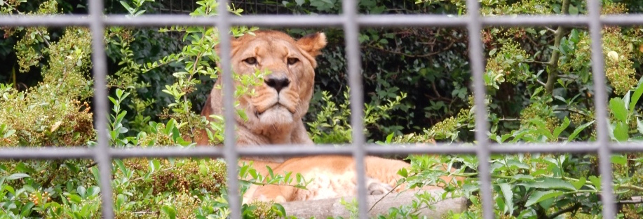
I learnt about Barbary lions on a visit to the Port Lympne Animal Park in Kent where there’s a pair of lions housed near one of the cafes.
The Animal Park is owned by wildlife conservation charity The Aspinall Foundation2 and is known for work to breed rare and endangered species for release into the wild. It’s also home to the world’s largest ‘gorillarium’ – which is a word I can only find in relations to Port Lympne – yet watching gorillas & lions in their cages is a strange experience. I know they’re effectively extinct and therefore the charity’s work is invaluable but these animals are still in an enclosure – large as it may be. On balance, though, the work has got to be worth it.
I spent a night in one of Port Lympne’s amazing ‘treehouses’3 which feature unforgettable views across the park and across Romney Marsh with, what I think, was the wind farm in the far distance. A complimentary golf buggy allows you access to the park after the day crowds have gone when, at dusk, some of the animals seems to be more awake. It’s possible to get quite close to some animals and watch them in fairly natural habitats. Many of the 600 acres are devoted to the African Experience where, from the safari vehicles, giraffes & black rhinos can be seen wandering the park.
It’s a brilliant experience to see the conservation work of the park up close. If you’re thinking of somewhere for an unusual night, surrounded by the sounds of safari, then Port Lympne comes highly recommended. The accommodation and the staff were superb and, if the thought of the 35 steps to the treehouse and to see the amazing balcony views is a bit daunting, take the golf buggy around the back.
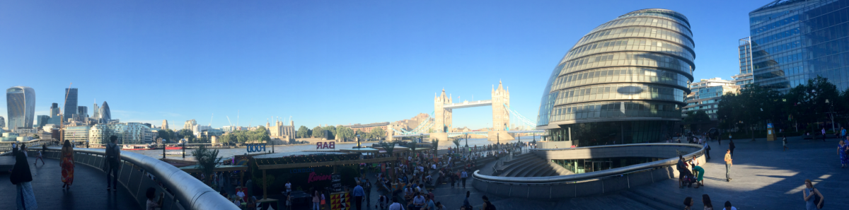
Each morning as I walk across the Thames, I look to my left and see the sights of St Paul’s Cathedral, the gherkin and Canary Wharf. It’s an amazing – almost iconic – skyline. Although radically changed with the modern skyscrapers, can you imagine what it must have been like just over 70 years ago when a hundred or more doodlebugs, or the V-1 flying bombs as they were more officially known, could be filling the sky and you didn’t know what their target was.1
Early in the second world war, London had been bombed by the German Luftwaffe – a period known as The Blitz. In spite of early attempts by the government to lock them, Londoners took shelter in many of the city’s Underground stations. In addition, parts of the Underground were used to store national treasures. Today it’s on an unused branch line, but in the 1940s Aldwych tube station, that I visited once before, protected artefacts from the British Museum from the damage aerial bombing could inflict.
At the height of the bombing, there were demands from the public for the government to provide more shelters. The government turned to the London transport authorities – who had the technical experience building below ground – to build new shelters. And, even though the bombing raids over London had subsided, a total of 8 deep-level shelters we’re built (although 10 had been commissioned). All the new deep shelters were built near existing tube stations: the unrealised dream being to bring them into service as railways post-war.
The shelters were eventually used for their intended purpose in the latter years of the war when, in June 1944, the flying bombs were sent to attack the city.
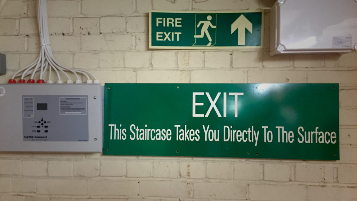
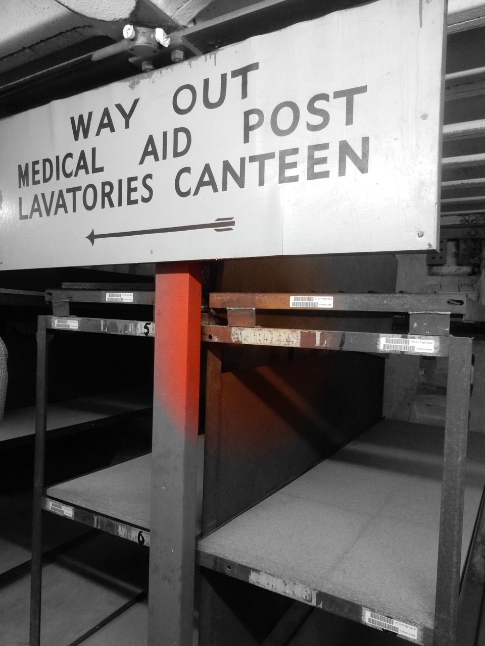
Last Sunday, as part of London Transport Museum’s Hidden London series,2 I visited the deep-level shelter at Clapham South. The above-ground pillar box can still be seen just around the corner from the existing tube entrance. The shelter is connected to the station but the walls have long-since been sealed forcing visitors to descend (and return later) via a 180-step spiral staircase. The lift, it appears, either not in working order or no longer fit for public use. It’s not easy on the knees but, somehow, not quite as many steps as it sounds.
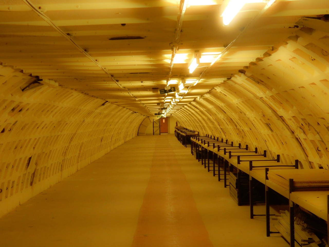
Below ground is a fascinating place. Wartime pictures of the shelter show the kind of Blitz-spirited Londoners that only seem to appear on old newsreel films.3 In reality, the space built for almost 8,000 people, must have been cramped, crowded, smelly and – probably – very loud. Even with the welcome addition of the canteen-served jam tarts that were not subject to the ration book, I can’t imagine it was the nicest of places. Admittedly, the feeling of 120 feet of earth above you probably went a long way to making it a sanctuary from the horrors above the ground.
The tunnels through which you are escorted on the tour are astonishingly clean & tidy – having been most recently used as a secure archive storage facility – but it’s clear from the remaining bunk beds that life would have been cramped. Row, upon row, of the stacked bunk beds could have given almost 8,000 people safety in the Clapham South shelter; your particular bunk marked on the ticket required to access the shelter. Most people would have to bring their belongings down in to the shelter each time they went; exceptions were made for people whose houses had been destroyed by the war. That’s 180 steps with mattresses and other personal items that you wanted to keep with you.
Post-war, the shelters have been used as a hostel for visitors to the great exhibitions of the Festival of Britain in 1951, places for incoming migrants to stay until they found permanent accommodation or as army barracks. In later years, the Clapham South shelters were the aforementioned storage facility while a nearby tunnel, that you don’t visit, is today used to grow salads under LED lighting.4
Walking across the Thames bridges in the August sunshine is a world away from the realities of wartime in the city: the Hidden London deep-level shelter tour a small, but important, reminder of what people went through and a fascinating insight into the ingenuity of the city to protect citizens in more difficult times.
Hidden London
If you’re interested in the Hidden London series of tours, visit the London Transport Museum site to see when the next series is scheduled.
About BEWA 2016
BEWA (Blog Every Wednesday in August) is a project aimed to get me writing in a blog style again. I wrote an introduction to kick the series off while the first proper entry championed an Olympic legacy. The third discussed my fascination with location data while what should have been the fourth entry was more of an Oops. There is a page with the #bewa collection (including those from last year). Fingers crossed I am back next week. I’m sure @curns will mention it.
In my head I am imagining the thousands who rose early to read a thrilling, pithy and insightful page of words from me over their morning coffee and artisan baked breakfast product.
Oops. My Blog Every Wednesday in August project (#BEWA) came slightly unstuck last week, didn’t it? In my head I am imagining the thousands who rose early to read a thrilling, pithy and insightful page of words from me over their morning coffee and artisan baked breakfast product. Each and every one of their days spent constantly f5-ing (for the PC nerds) to no avail.
The real world caught up with me and events on the first three nights of the week transpired to keep me away from the keyboard. I, of course, could have simply promoted the current BEWA series and pretended that was a worthy entry. It could have featured a handy numbered list something like this:
I did neither, choosing instead, to have another beer and then by the weekend, it seemed ridiculous to write an almost week-late entry. But the BEWA project has not lapsed. It’s back with a suitably stunning entry that might start with a reference to the London skyline (although perhaps not the one used here).
A little research tells me that reality TV personalities Kirstie Allsopp and Phil Spencer first entered our lives in May 2010 when “Location Location Location” appeared in the Channel Four schedule for the first time.1
Location was the buzzword of 2010. It was the year that Foursquare entered the mainstream, having launched the previous year2 and January 2010 was my first location-based check-in on the service (The Cardinal Cafe inside 80-100 Victoria Street in London, if you’re interested).
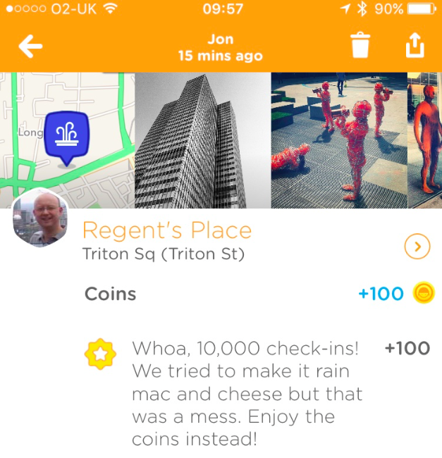
Fast-forward six and a half years (I’ll say that again: six years) and last Friday I passed 10,000 check-ins. Check-in number one was the aforementioned cafe outside my office at the time; check-in 10,000 was the square outside my current office. That averages just over 4 check-ins for each of the 2380 days between 29 January 2010 and 5 August 2016. And, although it has no real significance, it turns out that both were on Fridays which I take as a sign of something. Although I don’t know what.
A couple of years ago Foursquare separated into two: the Foursquare app removed checkin-ins and the gamification of location data to focus on reviews and recommendations of places you might want to go. Check-ins, mayorships and the other signals of location moved to the Swarm app. I kept checking in.
The company used the game to build up an impressive (maybe the most impressive) database of places on the planet. And, unlike most other directories, this was a database of places and how popular (or trending) they were at any point in time. Critical to the value of the data is that Foursquare can understand how people move between places. Check-out the pulse of London to get an overview of behaviours at a city level.
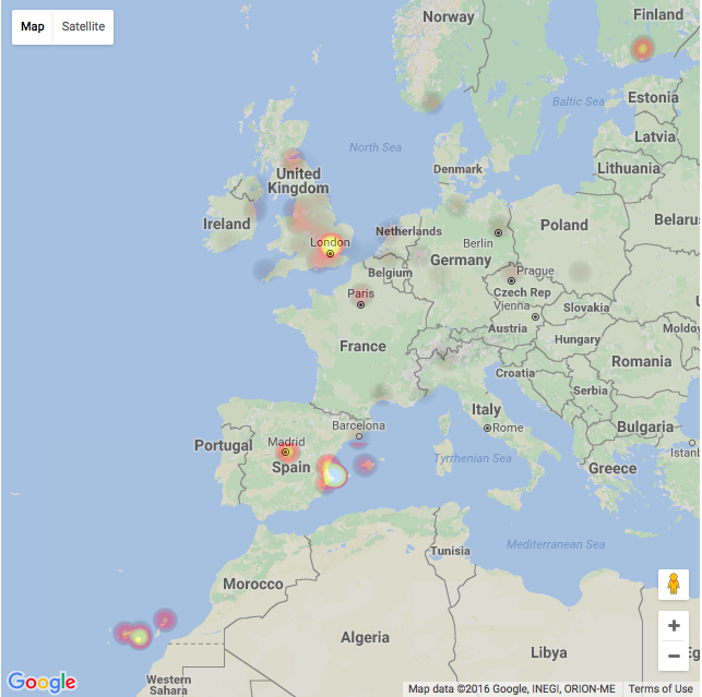
10048 check-ins mapped by Where Do You Go
I’m fascinated by this kind of data and what it can tell us about ourselves and our society. Each of my check-ins is sync’d to a calendar so that I could, in theory, look back where I have been. I don’t do that very often. A few years ago when I was spending a lot of time in Melbourne for work I generated a heat-map of the locations I visited just to see where I was spending time. It’s interesting to see the map but it’s not that useful. I’ve just generated another one for Europe3.
The Swarm app itself tells me more than half of my check-ins are at railway stations followed closely by coffee shops, offices, hotels and bars. I wonder how accurately that sums up my life? Is it that useful to me?
Occasionally, people see me opening a phone, selecting the Swarm app and doing the little check-in dance and wonder why I am still playing a game that many people stopped playing when the free beers for Mayors vanished. I think it’s an interesting question and, besides the fact that I do have a calendar showing the places I’ve been to, I’ve been wondering why I do it. I think I do it because the value isn’t only in the chronological history of my travels but how my experiences are useful to informing others.
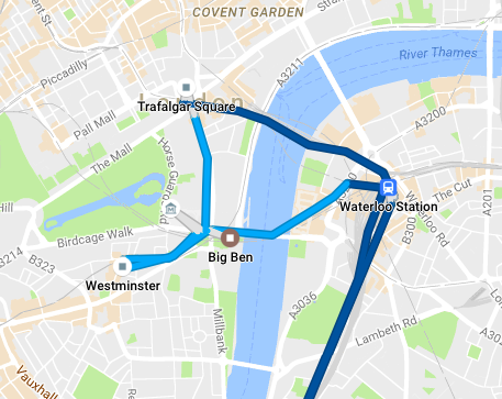
A day in the centre of London tracked by Google
I find maps so fascinating that, much to my frustration, I’ve spent many hours trying to make Apple Maps accurate for places around my house. For some reason I regularly resubmit more-or-less the same data. I’d love my phone to store a history of every journey I have taken and show them on a map and save them for future historians (a little like Google Maps can do for you). Can you image how amazing it would be to be able to see the paths our ancestors took around towns and cities of the past? The lessons we could learn!
I think Foursquare is the best alternative to those maps and historians will find their data critical for research. But, their database seems to be to be getting more and more accurate. And their ability to suggest interesting places is improving which means it’s also valuable to us today.
When travelling I find Foursquare particularly useful. That great breakfast place in San Fransisco when I was last there? Discovered on Foursquare. Oh, and the one I found the next day that was quiet but had great coffee was added to the database to help the next traveller in the area. This globally shared database of places, tips and tricks is invaluable when on the road and I’m happy to add my recommendations.
In his book Skyfaring, Mark Vanhoenacker has a theory he calls place-lag: a jet-lag like feeling of disconnect when you’re in a place suddenly very different from the last you were in.4 A feeling that is most commonly felt because of long distance air travel when your presence is the only real connection between two locations. Yet Foursquare – and similar – is able to make far off towns feel more familiar because it’s developing the powers to recommend places that we’ll like.
An understanding of place is critical to everything from taxi-hailing apps to controlling your heating (my heating knows when I am moving away from home and suggests I turn the temperature down ). We’re already hooked on GPS navigation systems but they’re improved when they understand not just where something is but how it relates to the world (which is the best entrance to the building from this direction?).
And an understanding of place is increasingly useful to the advertising industry. When I was first using Foursquare I discovered offers around San Fransisco that encouraged me to visit new places. They don’t seem to have Mayoral Specials any more but, nonetheless, if advertising’s ultimate aim is to give to you the right message, via the right medium, at the right time then knowing where you are is vitally important. Knowing where you are is more than just reading coordinates from a GPS system: it’s truly understanding the place you are in.
And these are all reasons I keep checking-in with Swarm. Every little piece of information is helpful to somebody’s future need to understand place. I want to help the world understand that the popular coffee place is inside the station rather than the one outside; that the best entrance when driving to the supermarket is the one on the other road and that people around here are looking for dinner and an offer right now could help somebody decide to where to eat.
So, even if mine is just a very small piece of the location jigsaw it’s all adding to the vast knowledge of places that helps everybody else. Clicking a little check-in helps build a better data set. And it gives me a lovely history of where I have been.
Here’s to the next 10,000.
About BEWA 2016
BEWA (Blog Every Wednesday in August) is a project aimed to get me writing in a blog style again. I wrote an introduction a couple of weeks ago and the first in this series championed an Olympic legacy. There is a page with the #bewa collection (including those from last year). Fingers crossed I am back next week. I’m sure @curns will mention it.
In December each year I post a set of photographs that sum-up the year for me. It started many years ago, before cameras on phones were commonplace, because it struck me how differently pictures taken on a phone represented the year in comparison to those on a traditional camera (which only ever gets taken when you think you’ll need one). If you look back at the pictures from the end of 2012 you’ll see a collection that features the Games of the XXX Olympiad, or London 2012 as I knew it.
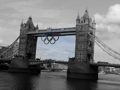
On Friday night, I imagine quite late London time, the opening ceremony of the Games of the XXXI Olympiad (Rio 2016) will take place at the Maracanã Stadium and Rio de Janeiro will have the honour of hosting the most recent games. As memories of London fade, perhaps only appearing in words like mine – when I summed up the feeling of being there for the opening ceremony rehearsals – the beaches of Copacabana or Ipanema will be the newest images of the Olympics, replacing in the mind, perhaps, images of the Olympic rings on Tower Bridge. Time, then, to wonder what we are left with in London.
Back in the bid phase for the London games, Tessa Jowell, then Secretary of State for Culture, and Ken Livingstone, Mayor of London at the time, argued for the games because they believed in the legacy. As Tony Blair notes,
They argued strongly that the Games would have a twofold legacy: the regeneration of the East End of London and helping build sport into the lives of a generation of children.1
I’d argue that the games were worth it for the atmosphere, enthusiasm, national pride and the spectacle at the time, but did we get a legacy? The Guradian recently suggested that we did not, particularly of the sporting kind,
For all the golden memories of July and August 2012, already tinged in sepia, and the continuing debate about the success or otherwise of the other legacy aims it is hard not to conclude that a prize Jowell once called “the greatest in a generation – faster progress towards a healthier nation” is not already close to being squandered.2
But, recognise anybody in the photograph? Perhaps you can’t because the picture is too small and they were moving too fast for me. They are the elite men cyclists in the Prudential RideLondon-Surrey Classic passing through Parliament Square on their way to the finish line. It’s part of an annual two-day cycling festival that sees almost 100,000 people cycle around the city on roads cleared of traffic for the day and hundreds more leave the Olympic Park for the Surrey Hills on a route not dissimilar to the one taken during the 2012 games. An event started as a direct result of the popularity of the cycling events in 2012.
All those cyclists in London in the year that Bradley Wiggins, who was an Olympic gold medalist on 2012, won this year’s Tour de France.
I think there’s a legacy right there. Perhaps cycling is the sport to take events at Box Hill & the velodrome forward to inspire a future generation of athletes.
But what about this single example? Thousands of young people who have a new gymnastics club as part of the legacy? Without it, “possibly 5,000 kids wouldn’t have a venue,” said a recent report on ITV News.3 And I could call out the reported 50,000 season tickets West Ham have sold for their new ground in the former Olympic Stadium (apparently the second highest season ticket sale in the Premier League).4
You can see regeneration in the Queen Elizabeth Olympic Park as both a public & event space. This summer there are sporting activities for kids with ‘Fit For Sport’ as well as the ArcelorMittal Orbit slide and the whole aquatics centre for swimming and diving. And if Olympicopolis comes to fruition, London will have a new cultural hub in in the heart of an area regenerated by the London games.5
And don’t forget Adam Hills, Alex Brooker and Josh Widdicombe are on our televisions every week thanks to the legacy of the Paralympic television coverage.
We may not all have taken up more sport as a result of The Games but I think there’s plenty of things we can be proud of that are part of the legacy of London 2012.
Last Sunday, watching both the ammeter and professional riders pass buildings representing our great institutions – Parliament, Westminster Abbey & the Supreme Court – there was also something else happening. A little of the spirit of the games came back with the cheering crowds and even those with limited interest in the sport of cycling searching for somebody who knew who was in the lead. That positive, optimistic and friendly feeling that 2012 brought us returned, even for just a moment in our post-Brexit malaise.
Perhaps, it’s not just the infrastructure or the number of people taking part in sport we should be looking to as the legacy of the games. The games brought out a spirit in almost everybody. We should hold on to that. I believe that would be the greatest legacy of all.
About BEWA 2016
This is the first entry for 2016’s BEWA (Blog Every Wednesday in August). The introductory post was written in July but you might want to read it anyway. All the BEWA posts will be tagged and you can follow @curns on Twitter to see the hashtag every Wednesday.