Although it was not squeezed in anywhere – the grounds of the old house were substantial – it was squeezed in
When I was 14 years old, my family moved house to a place on the road into (or out of, depending on where you are heading) Shrewsbury, Shropshire. In my mind, I probably have a bunch of stories buried from that time. But one thing that sticks out from the first months (or maybe years) that we lived in Shrewsbury was how difficult it was for anybody – including, at times, the Royal Mail – to find our house.
We moved to a newly built house with an address supplied by the Royal Mail. But the building was in the grounds of another, much older and grander, house and our patch of land was out of view when looking from the main road. Although it was not squeezed in anywhere – the grounds of the old house were substantial – it was squeezed into the postcode and numbering system that existed along the road. It was 89a and, a few years later, we were joined by a second new build home imaginatively numbered 89b.
If we’d been dwelling in a property along the main road, perhaps a property split into multiple units, then I think that deliveries would have easily found us. But, being out of the way, behind the trees, it was hard for people to know we were there. When talking to visitors, I was able to describe the post box on the street and the driveway to the right, which needed to be followed. In the days of online delivery, where every address is database-matched, it was harder to leave instructions for somebody to actually locate the front door.
Last week, I was introduced to a piece of technology and a mapping algorithm that would have solved all of that. In fact, there are a lot of problems this solves. For example, I work in a large building in central London. The main entrance is on one street, while the goods entrance is around the back on another street. But they have the same address. Think about how many times your GPS has taken you to the front door of a building when you’re actually in a vehicle and need the car park at the rear. Or what happens if you need emergency help, stuck in the middle of the countryside at a site devoid of a postcode and a building number?
I haven’t written about too many technologies recently, but the possibilities for this one are amazing. If your shopping is to be delivered by drone, then it’s much better to give them an address that is actually your roof terrace or your back garden rather than the pavement in front of your door.
So, do go and get what3words (there’s an app). They have divided the world into a grid of 3m x 3m squares and assigned each one a unique 3-word address which is easy to remember, clearly located and remarkably simple to use. You are able to talk about specific locations, in multiple languages, with real, recognisable word sequences. Words are easy to remember and, usefully, are simple for voice assistants to understand.
A little research tells me that reality TV personalities Kirstie Allsopp and Phil Spencer first entered our lives in May 2010 when “Location Location Location” appeared in the Channel Four schedule for the first time.1
Location was the buzzword of 2010. It was the year that Foursquare entered the mainstream, having launched the previous year2 and January 2010 was my first location-based check-in on the service (The Cardinal Cafe inside 80-100 Victoria Street in London, if you’re interested).
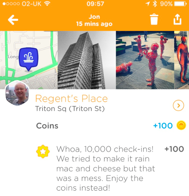
Fast-forward six and a half years (I’ll say that again: six years) and last Friday I passed 10,000 check-ins. Check-in number one was the aforementioned cafe outside my office at the time; check-in 10,000 was the square outside my current office. That averages just over 4 check-ins for each of the 2380 days between 29 January 2010 and 5 August 2016. And, although it has no real significance, it turns out that both were on Fridays which I take as a sign of something. Although I don’t know what.
A couple of years ago Foursquare separated into two: the Foursquare app removed checkin-ins and the gamification of location data to focus on reviews and recommendations of places you might want to go. Check-ins, mayorships and the other signals of location moved to the Swarm app. I kept checking in.
The company used the game to build up an impressive (maybe the most impressive) database of places on the planet. And, unlike most other directories, this was a database of places and how popular (or trending) they were at any point in time. Critical to the value of the data is that Foursquare can understand how people move between places. Check-out the pulse of London to get an overview of behaviours at a city level.
10048 check-ins mapped by Where Do You Go
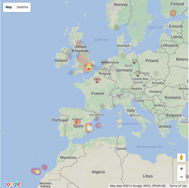
I’m fascinated by this kind of data and what it can tell us about ourselves and our society. Each of my check-ins is sync’d to a calendar so that I could, in theory, look back where I have been. I don’t do that very often. A few years ago when I was spending a lot of time in Melbourne for work I generated a heat-map of the locations I visited just to see where I was spending time. It’s interesting to see the map but it’s not that useful. I’ve just generated another one for Europe3.
The Swarm app itself tells me more than half of my check-ins are at railway stations followed closely by coffee shops, offices, hotels and bars. I wonder how accurately that sums up my life? Is it that useful to me?
Occasionally, people see me opening a phone, selecting the Swarm app and doing the little check-in dance and wonder why I am still playing a game that many people stopped playing when the free beers for Mayors vanished. I think it’s an interesting question and, besides the fact that I do have a calendar showing the places I’ve been to, I’ve been wondering why I do it. I think I do it because the value isn’t only in the chronological history of my travels but how my experiences are useful to informing others.
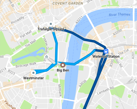
A day in the centre of London tracked by Google
I find maps so fascinating that, much to my frustration, I’ve spent many hours trying to make Apple Maps accurate for places around my house. For some reason I regularly resubmit more-or-less the same data. I’d love my phone to store a history of every journey I have taken and show them on a map and save them for future historians (a little like Google Maps can do for you). Can you image how amazing it would be to be able to see the paths our ancestors took around towns and cities of the past? The lessons we could learn!
I think Foursquare is the best alternative to those maps and historians will find their data critical for research. But, their database seems to be to be getting more and more accurate. And their ability to suggest interesting places is improving which means it’s also valuable to us today.
When travelling I find Foursquare particularly useful. That great breakfast place in San Fransisco when I was last there? Discovered on Foursquare. Oh, and the one I found the next day that was quiet but had great coffee was added to the database to help the next traveller in the area. This globally shared database of places, tips and tricks is invaluable when on the road and I’m happy to add my recommendations.
In his book Skyfaring, Mark Vanhoenacker has a theory he calls place-lag: a jet-lag like feeling of disconnect when you’re in a place suddenly very different from the last you were in.4 A feeling that is most commonly felt because of long distance air travel when your presence is the only real connection between two locations. Yet Foursquare – and similar – is able to make far off towns feel more familiar because it’s developing the powers to recommend places that we’ll like.
An understanding of place is critical to everything from taxi-hailing apps to controlling your heating (my heating knows when I am moving away from home and suggests I turn the temperature down ). We’re already hooked on GPS navigation systems but they’re improved when they understand not just where something is but how it relates to the world (which is the best entrance to the building from this direction?).
And an understanding of place is increasingly useful to the advertising industry. When I was first using Foursquare I discovered offers around San Fransisco that encouraged me to visit new places. They don’t seem to have Mayoral Specials any more but, nonetheless, if advertising’s ultimate aim is to give to you the right message, via the right medium, at the right time then knowing where you are is vitally important. Knowing where you are is more than just reading coordinates from a GPS system: it’s truly understanding the place you are in.
And these are all reasons I keep checking-in with Swarm. Every little piece of information is helpful to somebody’s future need to understand place. I want to help the world understand that the popular coffee place is inside the station rather than the one outside; that the best entrance when driving to the supermarket is the one on the other road and that people around here are looking for dinner and an offer right now could help somebody decide to where to eat.
So, even if mine is just a very small piece of the location jigsaw it’s all adding to the vast knowledge of places that helps everybody else. Clicking a little check-in helps build a better data set. And it gives me a lovely history of where I have been.
Here’s to the next 10,000.
About BEWA 2016
BEWA (Blog Every Wednesday in August) is a project aimed to get me writing in a blog style again. I wrote an introduction a couple of weeks ago and the first in this series championed an Olympic legacy. There is a page with the #bewa collection (including those from last year). Fingers crossed I am back next week. I’m sure @curns will mention it.